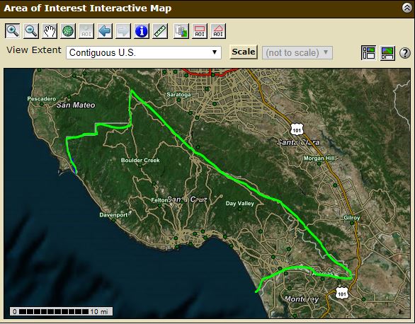
 |
| https://websoilsurvey.sc.egov.usda.gov/app/WebSoilSurvey.aspx |
The entire report can be found here
Click image below to make larger.
 |
- Sandy soil
- light, warm and dry
- dry and nutrient sparse
- high sand to clay ratio
- easy water drainage
- Clay soil
- retain moisture and cold in the winter
- dry out in the summer
- typically >25% clay
- Silt soil
- light and retain moisture
- very fertile
- can wash away easy in rain due to small particles
- Peat soil
- high in organic matter
- retain moisture
- usually added to gardens as it is not found naturally
- Chalk soil
- highly alkalized
- not ideal for plants that require acidic soils
- Loam soil
- mixture of sand, silt and clay
- fertile
- good drainage
- ideal for growing
REPORTS OF SOIL IN STUDY AREA
Approximately 35% of the study area in Santa Cruz county is classified as 'loam'. As the central coast borders the central valley (which is considered an area with possibly the best soil in the world) it does not come as a surprise that much of the soil on the central coast here, despite all of the sand, is still decent for agriculture. Much of the central coast below Aptos is used for agriculture (mostly Watsonville).
 |
| An aerial view of Watsonville, which sits on the coast in between Santa Cruz and Monterey. https://trip101.com/article/best-things-to-do-watsonville-ca |
Much of the area is covered in slopes as the central coast has the Santa Cruz mountains and many areas of rolling hills. Another 35% of the soil on the map is complex (areas of mixed soil) and is on average about 50% slopes or more. Most of this area is on south-eastern part of the map and includes the large state park that runs from the mountains down to the coast.
The soil survey also includes individual reports relating to land management, development, soil health, productivity, water and waste management and more.
Left: an example of what reports are available for the selected study area via the 'Soil Data Explorer' tab. Each category has a stop down menu (see 'soil health' for example) which allows you to go further in depth.
Of that areas in Santa Cruz county that are rated, all soil classify as slightly or moderately fragile. Reasons cited are: poor structure, low organic matter, semi-dry, vegetative cover, mildly wet, or strongly sloping.
Below: The only areas identified (circled in white) that reported having a surface salinization risk. Reasons given were: persistent water table, depth to saturation and existing electrical conductivity.
There are many other resources that this tool offers. Exploring soil further, you can read reports related to the suitability and use of the soil, the properties and qualities of the soil, and ecological assessments of soil sites. The ecological site assessment tab (pictured below) provides individualized reports based on the types of soil classified in the study area.

The map of the selected study area is highlighted and color and numerically coded by soil classification (right). Different types of soils are even broken down more in to categories, for example loamy soil is classified as: loamy. shallow coarse, fine, coarse bottom, bottomland and claypan. This is useful tool, especially for an area like Santa Cruz county where there are quick landscape changes from the beaches to forests to agriculture valleys.
SOURCES
USDA. "Custom Soil Resource Report for Santa Cruz County, California" United States Department of Agriculture. Retrieved from https://websoilsurvey.sc.egov.usda.gov/WssProduct/momb0x5olld4le43aohx3tbc/GN_00000/20190706_13120001640_73_Soil_Report.pdf
Soil types. (n.d.). Retrieved from https://www.boughton.co.uk/products/topsoils/soil-types/


Comments
Post a Comment